 Here is a link to information about the satellite Robin worked on years ago with an international team in Bristol, England:
Envisat Satellite Info
His simplified explanation:
The forward scan detects temperatures at the Earth's surface and buffers them. Later, the rear scan covers the same area but at a different angle and the values are compared to reduce the effect of the intervening atmosphere in each case.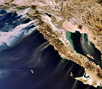 Here is one of the images it captured of the recent Southern California wildfires.


[get this widget]
Robin's Satellite
Wednesday, October 24, 2007
Posted by Vicky Jo at 10:58 PM
Subscribe to:
Post Comments (Atom)
0 comments:
Post a Comment